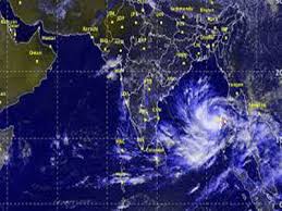
 BHUBANESWAR: the severe cyclonic storm ‘Hudhud’ 610 km from the state’s coast, the Odisha government today deployed rescue teams at vulnerable places and asked district collectors to begin evacuation of people, particularly in tribal dominated Malkangiri district.
“At least 25 teams, 15 of NDRF and 10 ODRF, have been deployed at vulnerable areas keeping an eye on the cyclone and heavy rainfall,” Special Relief Commissioner P K Mohapatra told reporters.
Malkangiri was this time in focus, Mohapatra said, adding the severe cyclonic storm was likely to pass over the district.
This would create a lot of rain in undivided Koraput district comprising Koraput, Malkangiri and Rayagada.
Other districts which would be hit by the cyclone were identified as Koraput, Malkangiri, Rayagada, Kandhamal, Kalahandi, Nayagarh, Gajapti and Ganjam.
Mohapatra said all the districts have been provided with satellite phones for emergency and constant vigil was being maintained on the rivers like Bansadhara, Rusikulya and Nagabali as heavy rain is expected in southern districts.
“We have asked the collectors that no one should remain inside ‘kutcha houses’ in Malkangiri district. All the people living in ‘kutcha’ houses need to be evacuated to safe place,” Mohapatra said, adding that this was being done keeping the state’s commitment of “zero casualty” as target.
The SRC also asked the district authorities to start free kitchen where the government undertakes evacuation drive. The districts are also told to stock adequate quantity of dry food, he said. (More) PTI AAM CR
Meanwhile, the latest bulletin issued by the IMD said that the severe cyclonic storm over west central and adjoining east central Bay moved northwestwards and lay centered at 0530 hrs IST of October 10, 2014 near latitude 14.4?N and longitude 87.6?E over west central & adjoining east central Bay about 610 km south-southeast of Gopalpur.
“The system would move west-northwestwards, intensify further into a very severe cyclonic storm in the next 12 hours. Thereafter, it would cross north Andhra Pradesh coast around Visakhapatnam by the forenoon of 12th October 2014,” it said.
The Paradip and Gopalpur ports in Odisha were advised to hoist local cautionary signal number 3 (LC-III) as the severe cyclonic storm got closer to the Odisha-Andhra coast.
The storm, which is gathering more force, is likely to turn into a very severe cyclonic storm within next 12 hours, the IMD warned.
The bulletin warned of heavy to very heavy rainfall at one or two places over South Odisha during next 24 hours and heavy to very heavy rainfall at a few places over South Odisha in the subsequent 48 hours.
Rain/thundershower would occur at many places over Odisha during next 24 hours and rainfall will increase in subsequent 48 hours in Odisha, the bulletin predicted.
The bulletin also said squally wind speed reaching 45-55 kmph and gusting to 65 kmph from northeast direction would prevail along and off the Odisha coast and the wind speed would increase to 80-90 kmph along and off Odisha coast from the October 11 evening.–PTI


